Archive for November 2009

More GNIS maps

November 27, 2009

Following up on my previous post about the geographic distribution of creek and brook place names in the US, here are a few other maps I made, looking for interesting regional patterns.

First a few more stream-related maps.

This map shows streams whose names end with “branch” and “run”. Branch is a common term throughout the South. Run coincides with the North Midland dialect area, as George R. Stewart puts it. It is a common term in the Appalachian Mountains of Pennsylvania and northern West Virginia. In southern West Virginia the term “branch” is generally used instead of “run”. There are some small areas where “run” place names are particularly dense, especially in north-west and north-central Pennsylvania and northern West Virginia. My map doesn’t show these smaller patterns very well because my dots are large enough to merge into a mass of red. Stewart explains that in colonial times, when these patterns emerged, “run” became a common term for the smallest of streams, while “creek” was used for larger ones and “river” for the largest.

This map shows streams whose names end with “run” and “slough”. The distribution of “run” streams is clearer than in the previous map. I’m not sure whether there is much of a pattern with “slough” and don’t know much about the term, its origin and history.

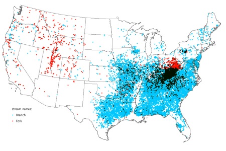
This map is like the others, but showing streams whose name ends in “branch” or “fork”. There’s a curious concentration of streams named “fork” in the Appalachians of West Virginia and Kentucky. Usage is scattered elsewhere with smaller concentrations in the West, especially in Utah.

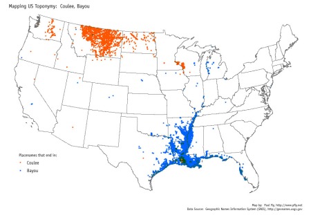
One more map about streams. This one showing those whose names end with “coulee” and “bayou”. Unlike the others, this map isn’t restricted to just streams, because “coulee” is a term used for dry canyons as well as streams. Most of the bayous shown are probably streams or inlets of the sea. As expected, the term occurs almost exclusively in the lower Mississippi River region and along the Gulf coast. The usage of “coulee” has an interesting regional pattern. There are four distinct areas where the word is used, and it means slightly different things in each case. The first area is in Lousiana, and is hard to see on this map because it overlaps with “bayou” so much. It is used there for small streams. A friend of mine who lives in southwest Louisiana says a coulee is a stream narrow enough to step or jump across. A second area of usage is found along the upper Mississippi River in Wisconsin and Minnesota. Here the word is used for small, short, steep streams. A third area is found in the northern Great Plains of Montana and North Dakota (extending into Canada as well). Here the word is “the equivalent of creek”, according to Stewart. Finally, in Washington “coulee” is used to refer to region’s unusual dry canyons carved from basalt, such as Grand Coulee and Moses Coulee.

I have a few more maps to write about, but will save that for next time.

Creeks and brooks

November 25, 2009

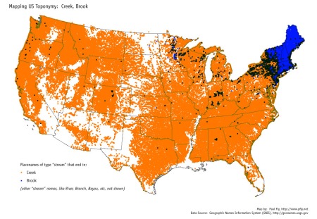
Some years ago I made a series of maps showing patterns in place names in the United States. The most striking one shows the strong regional pattern of naming streams “creek” or “brook”. I used the USGS’s GNIS database of place names, and ArcGIS to make queries and map the results. This brook-creek map shows a point at the mouth of every stream whose name ends with either brook or creek. In the GNIS database “stream” is a class that includes all “linear bodies of water flowing on the Earth’s surface”. So, creeks, brooks, rivers, bayous, forks, sloughs, and so on. This map shows only those named brook and creek. That is why there is a large empty area along the lower Mississippi River, where streams tend to have names like bayou. I’ll post some of the other GNIS maps later. The map is also online at Flickr, where I wrote a bit more about it.

Map showing streams in the US named brook and creek.

The creek-brook geographic pattern is explained in the classic book about place naming in the United States, “Names on the Land”, by George R. Stewart. It goes back to the earliest colonial times in New England and Virginia. People from England coming to America explored and settled coastal areas first, and began to establish place names for natural features like streams. Large streams were naturally called rivers, as they are in England. In Virginia there are many streams that broaden into tidal estuaries as they near Chesapeake Bay. The larger ones were called rivers. The smaller ones, which from the sea looked like small inlets washed by tidal currents, were called creeks. In England the word creek was mainly used for just that: not a stream per se, but a small inlet of the sea were tides flow in and out (see Wikipedia’s page Creek (tidal)). As they explored inland they came to the tidal limit and found the rivers and creeks flowing always one way, no longer effected by tides. And, as Stewart puts it, “since it seemed the same, they kept the same name for it. Thus a creek came to mean a flowing stream, although in England it meant, and still means, a tidal channel.” This way of naming large streams “river” and small ones “creek” spread from Virginia across most of the country.

New England was colonized nearly as early as Virginia, and it developed different patterns of place naming. A key difference was the land itself. Virginians were a “river people”, living in a land dominated by rivers and estuaries, while New Englanders were a “salt-water people”. In New England the coast rises more sharply from the sea and there are few long tidal channels that English people might call creeks. As in Virginia, large streams were called rivers, but small ones were most often called brooks, as in eastern England. The use of brook instead of creek spread throughout New England and west into New York, New Jersey, and parts of Pennsylvania—all areas that were settled by New Englanders in colonial times. But beyond this region the Virginian style of using the word creek came to dominate. There are only a few scattered areas where the word brook is used, most notably in Minnesota.

There are other regional patterns for stream names such as run, branch, stream, bayou, and coulee. I’ll post maps of those later.

Native Seattle: sdZéédZul7aleecH

November 24, 2009

Seattle is the only large U.S. city named after a Native American individual, Chief Seattle (spelled variously Sealth, Seathl, and elsewise). There are plenty of other cities with Native American names, but the only others named for an actual person are small. The largest I have found is Pocatello, Idaho, with a fairly sizable population of 51,466, named for the Shoshoni Chief Pocatello. Other, smaller examples include the city of Winnemucca, NV (pop. 7,174 and named for Chief Winnemucca), Pocahontas, AR (pop. 6,518, for Pocahontas of course), Red Cloud, NB (pop. 1,131, for Red Cloud), Tecumseh, MI (pop. 8,574), Tecumseh, OK (pop. 6,098), and a few others named for Tecumseh. There are a few cities named for Hiawatha, the largest of which is Hiawatha, Iowa (pop. 6,480). The city of Indianapolis was nearly named Tecumseh, but apparently Indianapolis was deemed better. So Seattle, with a population just under 600,000 and a metro area population in the millions, seems to be the only truly large U.S. city named for a Native American person.

For a city with a name like Seattle, you might think there would be Native American place names within the city. And there are a number of places that have been given native names, but of places that still have their pre-city (pre-conquest?) native names there is apparently but one. Licton Springs is today the name of a neighborhood in Seattle, north of Green Lake. The rust-red colored spring is still visible in Licton Springs Park. The natives who lived in Seattle before there was a Seattle spoke Whulshootseed. Licton Springs was known as lééQtud in that language, a word meaning “red paint”. Of course “lééQtud” is an attempt to render a Whulshootseed word into the latin alphabet, so it looks strange. The capital Q is pronounced like the c in “cool” (a “back k sound”), but with an explosion of pressure built up at the back of the mouth (glottalized). The double ee is pronounced as in English “meet”. I’m not sure what the accents are for.

A few other native place names have survived, but mostly those refering to tribes, bands, and groups of people, like Duwamish and Shilshole. Had other names survived instead of saying Pioneer Square we might say sdZéédZul7aleecH (yes, that is a 7 in there), which means “Little Crossing-Over Place”. It was the name of one of the largest native villages in what is now Seattle. It was located near the foot of today’s Yesler Way, right in the heart of Pioneer Square. Okay, we’d probably spell it slightly differently.

The information about native place names in Seattle comes from the book Native Seattle: Histories from the Crossing-Over Place, by Coll Thrush.